It is hard to believe that Kashmir and Ladakh belong to the same state (Jammu & Kashmir). On the one hand the verdant, exuberantly green Kashmir valley, on the other the high desert Ladakh tinged with mountain colors and topped by snowy Himalayan peaks. On the one hand Muslims bending down facing Mecca for worship, on the other ascetic Buddhists bending down for Buddha.
Ladakh
Our flight from Srinagar to Leh, the capital of Ladakh situated at 3,500 meters elevation (11,130 feet), was one of the most stunning mountain vistas I have ever experienced. We flew so close to the twin peaks Nun and Kun, both well over 7,000 meters, that it felt like we could bend down and touch them.
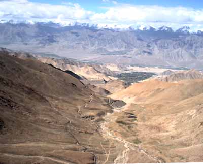
The landscape was amazing. A high altitude desert where the only vegetation grows near the rivers fed from snow melt. One of the world's mightiest rivers, the Indus, flows through Leh on its way down to Pakistan. The rest is multi-colored rock and sand. And high above, the tall and snow-capped Himalayan mountains.
The Ladakhis arrived from Tibet long ago. But even today the food and culture remains remarkably similar. They eat tsampa (barley) porridge, drink tea with salt and butter, and raise yaks. Buddhist monasteries are everywhere. We had visited several in Sikkim, but here they are much more common and older.
Visit any monastery and the Buddhists' love for spectacular locations will be obvious. Some are built on top of small hills, others have spectacular views, and others still cling to the steepest mountains high above the valley below. Many have 80 monks or more living there.
Both of us had read the National Geographic's article about Ladakh in the 60'es - long before we were married or knew each other. For Surain it had been an unreachable dream, for me something added to the list of places to be visited in the future. And now we were here! Though we found a lot Tibetan culture, craft, and people in Ladakh, it was obvious that twenty-five years of influence from India and foreign tourists had had its impact.
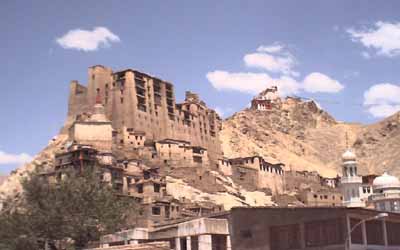
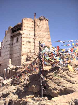
Leh has much to offer for the tourist. We gave ourselves a day to get acclimitized to the high elevation, and then started exploring. The Leh Palace sits high above the city. It was built in the mid-16th century, but is now mostly in ruins.
There are several monasteries around the palace area. Some of them flew prayer flags. But to our surprise, prayer flags were much more common in Sikkim than in Ladakh.
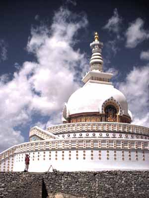
It was a stiff climb up to the Shanti Stupa, built in 1989 by the Japanese Nipponzan Mayohoj as a Buddhist shrine. The stupa is dedicated to world peace, and there are about 30 similar stupas around the world outside Japan - most of them in India and Sri Lanka. We had visited a similar - but even more impressive - stupa in Rajgir in Bihar about six weeks ago.
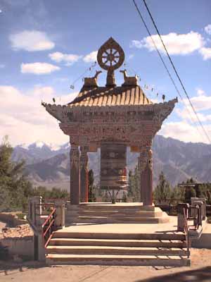
Buddhist prayer wheels are common in Leh. This one has a particularly good location with mountains in the background.
Ladakh's Nubra Valley
We had heard that the remote Nubra valley was much more pristine. So we hopped on a bus there ("hopped on a bus" sounds so easy. It doesn't mention the fact that we had to secure special permits to go there. And we had to get up at 4:30 a.m. to ensure two seats on the bus. And it took an hour for the bus to leave town. It had to fill gas, allow the driver to eat his breakfast, load gas cans for Nubra valley, etc., etc). For several hours the bus ground its way through steep switchbacks ever higher and higher. For a long time Leh was visible far below, but ever smaller and smaller.
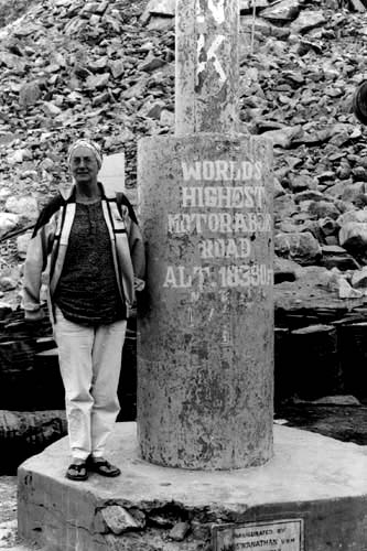
And then, finally, the bus stopped at a view point, but a very special view point. We were at the top of the "highest motorable road in the world", at an elevation of 5,602 meters (18,380 feet). (Yes, I know that some Bolivians would take exception to this statement). And yes, it was the highest we had ever been, even higher than Thorong-La (5,430 meters), where we had met almost 23 years ago (but it was neither as strenuous as hiking up Thorong-La on foot, nor as spectacularly beautiful).
We loved Nubra Valley. The locals were exceptionally friendly, everyone said "Jule" (Namaste) when we met them. There seemed much less impact of Indian development and hardly any foreign tourists at all.
We spent our time there trekking from village to village (we had even rented real boots for the occasion, with the punishment that our sandal-shod feet took on the trek to the source of the Ganga fresh in our memories ... see travel report #8). We visited both the two beautiful gompas (monasteries) there, one with the most spectacular setting of any of the gompas that we had visited.
The bus trip from Leh to Manali
Friends had told us that we had to take the two-day bus trip from Leh to Manali because of the stunning beauty, we “simply were not allowed to fly”. This road crosses the high Himalaya mountains in five high passes, from the foothills at Manali to Leh. It is closed from late October to June or July, depending on the snow cover.
Travelers who had actually taken the bus gave us horror reports instead, “It took five days. The army was clearing the snow and stopped traffic for three days. We had to wait in a tent camp.”, “We had a breakdown at the top of a pass and had to spend the night there in freezing cold weather.”, “The driver did not stop for the night but kept on driving for twenty-five hours.”. Several people had altitude sickness and complained of terrible headaches. Well, we were acclimatized by now, so we should at least not have THAT problem.
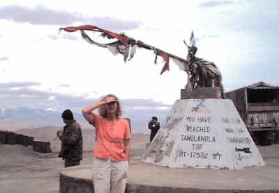
The bus left six a.m. from Leh on a sunny morning. After an hour's drive along the arid valley, it started to climb. It climbed and climbed and climbed. We soon left the villages behind. The road was narrow and it was difficult to pass. We did not meet many other vehicles, but a long convoy of military trucks held us up for half an hour. More climbing and then, finally, we reached the first and highest pass. We had climbed from 3500 to 5359 meters (11,130 to 17,582 feet), one of the highest roads in the world. It was cloudy on the other side of the pass. We descended to a high plateau. This was devoid of people and animals – except for the poor people maintaining the road. They slept in tents with nothing around them except sand, mountains, and lovely scenery. It clouded over more and started to drizzle.
The bus stopped for lunch several hours later. This was a military camp with a few tents set up to serve meals to people in buses like ours. After lunch the military checked the passports of foreign tourists for the fourth time. This area is close to the borders with both Pakistan and China and thus sensitive.
After we got the passports back we waited a long time when nothing seemed to happen. Finally, at 2:30 p.m., the conductor came by informing us that the military had deemed it too dangerous to continue through the next passes after 2 p.m., so we would have to remain here until the next morning, sleeping in the bus.
We were all shocked and chagrined. Remain here in this bleak area? This would also mean that the bus trip would take three days. Several Westerners talked to the military in vain. Indian passengers talked to the military. Several times the engine started up to return the bus to the tent area, only to be turned off again. Then at 3:00 the military smiled and waved at us to continue and we were off again. We were all exhilarated and cheered. What had happened? One of the Indian passengers was a military man, and he had finally managed to secure the passage. But if we met other military on the road, we were to blame our late arrival on a breakdown.
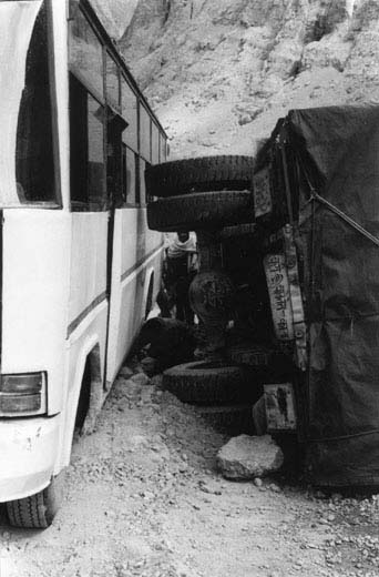
After fifteen minutes we had to stop at an overturned truck. Did I tell you about meeting vehicles from the other direction? For trucks and buses it is very difficult. One has to hug the mountainside, and the other one be on the edge of the abyss. Often this is not enough, so one of them has to back up a long ways to make meetings possible. And sometimes … well, this sometimes had happened today and the truck at the edge must have slid down and turned over. Fortunately no abyss today, just a fairly gentle descent to a river. It was clear that this must have happened within an hour. Any car trying to get past the overturned truck would have the truck wheels against its side.
Our bus driver tried to pass. He hugged the mountainside and very gingerly tried to squeeze by. It was just wide enough at the bottom, but not at the top, since the bus leaned to the side. How could we get by? How would YOU have solved it? Well, Indians are good at uncommon solutions. They found some fairly large rocks – not difficult, they were everywhere – and placed them just in front of the cliffside wheel of the bus. When the bus moved forward, the front wheel rolled on top of the rocks making it as high as the mountain side, so the bus would no longer lean towards the truck. Voila!!
The road was especially atrocious at this area. We had to snake through at times, wobbling from side to side worse than a camel. People at the back of the bus screamed loudly as they almost hit the ceiling at some of the bumps. Fortunately we were in the middle!
The rain increased as we started climbing again, higher and higher with every switchback. The scenery was magnificent, and reminded us of Bryce Canyon National Park in Utah (pillars of rock in odd formations). And finally we reached the second pass at 5,064 meters (16,616 feet). Down, down, down to another plateau. And then up, up, up again. We wondered if the driver did not get tired turning the wheel so many times. Then we noticed that the conductor sat next to him and grabbed the wheel at every switchback to spin it around. This third pass made us think of Machu Pichu in Peru. Sheer mountains plunged straight down to a river way below, carved out through the rocks.
There was a wide plateau again after the third pass. We reached another military checkpoint and showed our passports for the fifth time. This took about fifteen minutes. Back into the bus and another checkpoint. Why? The conductor explained that we had just left the State of Jammu & Kashmir and were now in the State of Himachal Pradesh. We don’t know what they did to these twenty passports, but it took forty-five minutes before we got them back. Our hope to reach the tent camp before darkness had waned.
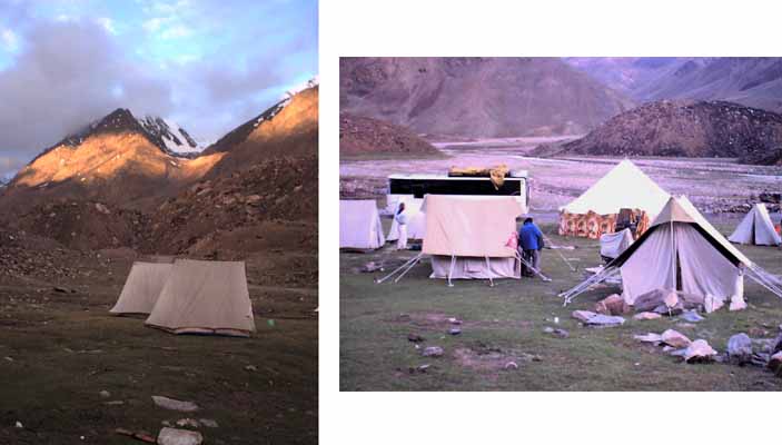
Tent camp? Yes, that is where bus passengers spend the night – except those who sleep in the bus to save money. Twenty minutes later we stopped at such a camp. The price was horrendous for what was offered, but Surain and I had no interest in bus camping, so we checked in to a two-person tent with blankets. It was nice to put on more clothes from our backpacks, since it was getting chilly.
We had all our belongings spread out in the tent, when there was a loud honking and we were informed that the bus was leaving. We threw things back into our backpacks and boarded the bus again, where people were waiting impatiently. It seemed like price negotiations with the tent owner had failed, so the driver had decided to continue to the next tent camp. Prices were actually a bit more reasonable there. At bed time the sky had cleared revealing incredibly crisp stars. At an elevation of 4,300 meters (14,108 feet), the night temperature was decidedly cold, but we survived under thick blankets.
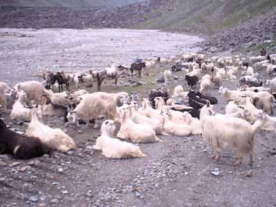
The second day did fortunately not have as much excitement as the first one. In the morning we crossed the fourth high pass and then dropped far down. This was a different climate zone with the high and dry plateau replaced by green vegetation, trees, big rivers, waterfalls, many glaciers in the mountains, all enchantingly beautiful. Herds of goats blocked the road many times. They were everywhere, on the road, in the steep hills grazing, down in the valleys. Dogs and goat herders worked hard to keep them together.
Before we reached Manali we had to cross the fifth pass, not a high one, since it was “only” 3,997 meters (13,019 feet). At the top of the pass there were literally thousands of people enjoying Indian sight-seeing – pony rides, holy temples, dress-up for pictures, etc. Unfortunately it was all shrouded in clouds. Down in Manali the monsoon had started.
Namaste - Robert