Baja Paddling instead of Seattle blues
By Robert afSandeberg (email robert@afsandeberg.com)
Distances are in nautical miles (1 nm = 1.15 statute miles).
We were planning to go to the San Juan Islands, NW Washington,
to do some kayaking and whale watching for Memorial Day weekend.
The resident pod of orcas is usually pretty easy to spot this
time of the year. Many people also talked about seeing gray whales
passing by. But as the cold and rainy weather wore on at the
end of May, Surain, my wife, said that she couldn't get excited
about San Juan and was longing for hot and sunny weather. After
the rainiest winter on record we were now experiencing the coldest
May I could remember.
The same day I called our travel agent and asked if there was
any place in Baja California, Mexico, that we could fly to within
a week's notice. We had kayaked in Baja four years ago and loved
it. Yes, La Paz was available. So a week later we had our folding
kayak, a Nautiraid Double Expedition, with us heading south.
As the plane touched down in La Paz the temperature was announced
as 94 degrees. I loved it already!
The most popular kayaking spot near La Paz is Isla Espiritu Santo.
It is a wonderful place, but since we had already been there,
we opted to go to Isla Cerralvo instead, about a 45 minute taxi
ride east of La Paz. We eventually got dropped at a lighthouse
south of Isla Cerralvo in the late afternoon. The place was full
of beached fishing boats and barking dogs. But what did it matter
- we were in Baja and could see and hear the sea lions breathe
as we pitched the tent. Schools of brown pelicans flew by as
a glorious sun sank below the horizon and a full moon rose.
Out to the island
The worst nuisance were the dogs barking during the middle of
the night. The fishermen started heading out at 6 am when the
day broke. We weren't long after them. There was a 5 nm crossing
to the closest point at the southern tip of Isla Cerralvo. Some
wind and swell slowed us down, but not nearly as much as the incredible
school of dolphins that swam by our kayak on both sides. Seeing
dolphins swim by so close that you can hear them breathe is one
of those unforgettable moments that we will remember for life.
The wind disappeared but the swells got rougher as we reached
the point and continued on the eastern side. There were many
sea lions barking noisily here. After almost two hours of paddling
we longed for a break, and a little bit further it looked like
the swells settled down and an inviting sandy beach beckoned to
be explored. But as we got closer the sand turned out to be large
gravel and the swells were still ominous. We had to do a surf
landing to get ashore. Except for the remains of some goats there
wasn't much here, so we soon continued.
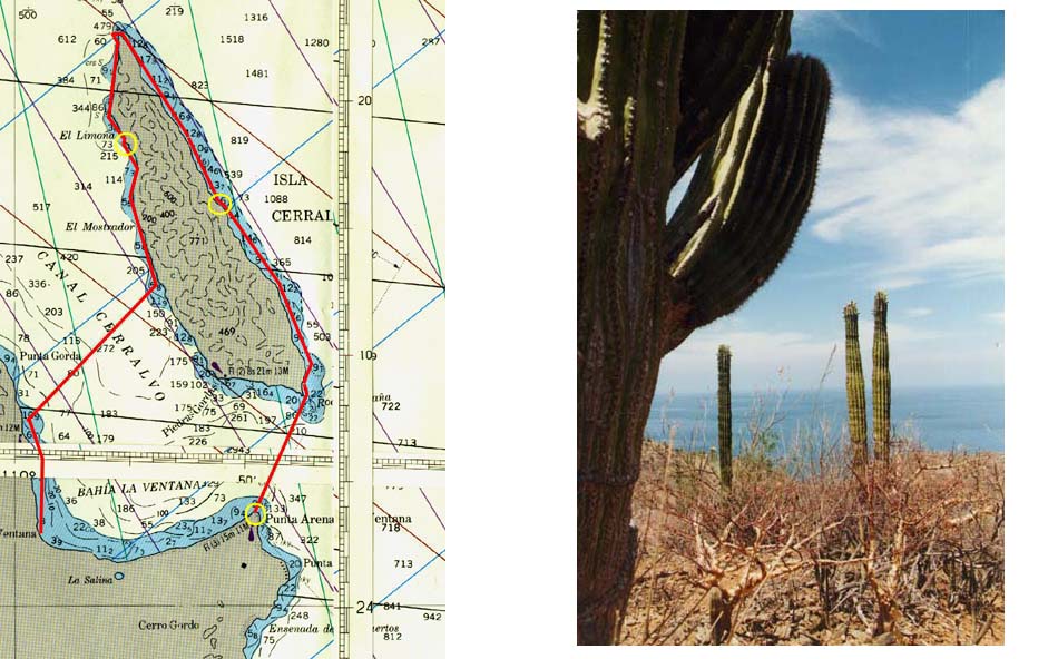
We found it fascinating to paddle along this semi-desert, which
we followed as closely as possible. It was not dead at all, but
teemed of life with the cacti being the prominent features. High
above us there were frigate birds and the ubiquitous pelicans
often passed by. At 12:10 we decided to call it a day. We had
reached an arroyo, or canyon, which would be easy to walk along
and explore the desert.
I was surprised that we had paddled 15% faster after reaching
the point than before. There wasn't that much wind. Were there
currents here?
Exploring the desert
Fully dressed with hat, long pants, and long sleeves - the sun
is fierce here almost at the tropic of cancer - and with cameras
and binoculars we set out in the arroyo. We could not but marvel
at all the different kinds of cacti that grew here. We were lucky
to find lots of them in bloom. Birds were pretty common, especially
the vultures. Sometimes we could hear a little noise among the
branches. With a little patience we could often see rabbits and
lizards. Far away there were goats high up on the slopes.
It was calm again the next morning. We passed close to a rock
full of birds resting there - pelicans, gulls and others, but
especially frigate birds, some with their red pouch. Though we
had seen these exciting birds a few times in the past, this was
the first time we had seen them "landed" since Galapagos
Island 18 years ago.
Further north the cliffs got higher and most of the vegetation
disappeared. There was red rock with striate white, then the
next rock was purple, then again there was a green cliff. Suddenly
the wind kicked up and it blew 10 knots with gusts about 15 in
our face. We would like to get past the northern point and steer
downwind before the wind was too strong. We pushed hard for 45
minutes and were helped along with a favorable current. But when
we got really close the wind died again and it was as calm as
ever with no wind and no waves.
There were a few Mexican fishermen at the point but otherwise
no activity. We rounded it and headed south on the western side
of Isla Cerralvo. Shortly after, we went ashore to stretch our
legs. We were going to push on to set up camp at lunch time,
but decided to explore the corals instead. The actual corals
weren't that interesting, this was a bit too far north, but the
fish life was surprisingly rich. There was a ray, several puffer
fish, pipe fish, a colorful sea anemone, and many more, large
and small, round and flat, shy and brave, orange, black, green,
red, blue, … a vast array.
After lunch we paddled another long hour until we found an inviting
arroyo. As we got closer we found a sign that said that the entire
island was a National Park and all wildlife was protected. The
island even had three indigenous plants (that exist no where else
on earth). As we explored this arroyo, we found the same wildlife
as yesterday, but the cacti were nicer and we saw lots of tiny
kolibris (hummingbirds).
Back at camp I read the chart carefully (I may be a bit sloppy
during the day). Yes, I had been a bit lazy. The first day we
paddled 14 nm, today 12 nm, so tomorrow we'll have to paddle almost
19. That could have been planned a bit better!
The big crossing
The wind rustled in the tent early in the morning and the swell
sounded louder. I knew that it is never as loud as it sounds
in the tent, but still … And it "never" blows
in Baja during the night. We were planning to do a 7 nm crossing
today. We had enough water and food to stay another day. But
would the twice-weekly non-refundable airplane wait for us? I
did not like to be in this situation.
I felt more relaxed as we got up. But the surf was definitely
stronger. The wind was slowly increasing as we followed the shore
early in the morning. But at one place we had to stop for a while
to marvel at the 60 goats near the beach, some of them walking in
the water. I let Surain out after two hours to stretch
her legs for a few minutes while I stayed just outside the surf
zone. As we started across to the mainland we noticed that there
were only whitecaps where there were tide-rips.
Past the tide-rips the wind was light from north. I had planned
to steer 235 degrees, but decided on 220 instead to take some
advantage of the prevailing wind. This would make the crossing
just slightly longer. But what was that out in the water? We
stopped paddling and looked closely. A large turtle! We kept
absolutely still and slowly glided past the turtle, which didn't
move.
After about an hour's paddling, when we were still not halfway,
the wind started increasing. There were soon whitecaps that kept
getting bigger. Waves started building. Should we be out here?
We no longer saw the horizon when we were down in the troughs,
which indicated waves of more than 2 feet high. In bigger waves
not only the horizon disappears, but also the mountain above it.
Some waves washed over the kayak, and though there were no real
streaks in the water, the whitecaps created a confusion of white
specks.
As we got closer to the other shore I estimated the wind to be
just over 20 knots. By this time I had turned the kayak downwind
45 degrees to avoid having to paddle sideways against the waves.
As we got even closer the waves got smaller due to the shallowness
and I turned straight downwind towards our destination. It was
now blowing even harder and there were whitecaps everywhere.
We drifted at least 3 knots without paddling. Even with very
leisurely paddling we flew downwind in 5 to 6 knot speed.
We arrived at the take-out point at the small town of La Ventana
at 12:10, much earlier than expected. We quickly broke the kayak
apart and hailed a local truck to take us back to La Paz, where
we enjoyed all the amenities of an interesting large Mexican city.
Conclusions
This was a very enjoyable kayaking trip to a fascinating island
with a desert-like vegetation. Nearby Espiritu Santo is more
interesting and is easier to get to and the crossing is shorter
- or you can take a panga across the 4 nm channel.
But Espiritu Santo also has some houses, other
structures, boats, kayaks, and tour boats. Cerralvo has none
of these, though there may be divers off shore. Both of them
have lots of Mexican fishing boats.
If you want to go yourself:
Air transfer: Alaska Airlines flies twice weekly from Seattle via LA. The Mexican airline Aero California also flies daily from LA.
Transportation from the airport: If you come with Alaska, you should be able to join the split taxi to Las Arenas, a nice resort near the lighthouse. From La Ventana we hired a local truck to take us back.
Distance: From the lighthouse via the 5 nm crossing to Isla Cerralvo, then along the east coast and rounding the top, down the west side to the closest crossing to the west, 7 nm, and then down to the town of La Ventana it is 45 nm (52 statute miles).
Water: There is absolutely no water available on the island so bring what you need. All water in Baja California is drinkable without treatment (not true for the rest of Mexico!). We figure 3 liters per person and day (18 liters or 4.8 gallons for the two of us for this three day trip). No other amenities available.
Charts: The only one we have found is a Mexican chart for southern Baja in the scale of 1:270,000. It's quite sketchy (the chart in this Web site is scanned from this chart). You'll need your dead reckoning skills to figure out where you are (Mexican land maps are much better but don't show any sea information).
Wind: Baja is known for very windy conditions in February,
March, and January (in that order) but fairly calm other months.
Early morning (until 10 or 11 am) it is usually calm even during the
windy months. We had no weather forecast to rely on.
Four years later, in 2003, I learned that La Ventana is the wind surfing capital of Mexico. Many fly down from the US to enjoy the strong winds. Had we known that, we may have decided against that crossing!